Highlights of the 2002 Excavations


John Roberts took over the direction of excavations in 2002 and began 5 years of supervision, developing a strategy of excavation which helped to increase understanding of the site in each year. Seventeen test pits were excavated in April, in the triangular field to the East of the Old Vicarage, to confirm that the boulder clay under the OV garden extended into this field. Several revealed patches of grey silt suggesting the presence of archaeological features and one held a definite post hole.

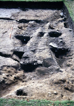
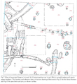
Trench 16 was positioned alongside Trench 3, which had been excavated and backfilled in 2000. It revealed a series of intercutting curvilinear ditches which may have been the drainage gullies of Iron Age Roundhouses, from which we were able to take samples. A Radiocarbon date was recovered which produced a date of between 380BC and 520BC. A second gave two date ranges of equal probability between 360BC and 410BC and the other 240BC and 280BC

One of the features was a stone lined gully very similar to the one found in Trench 3 in 2000. Another appeared to be a gully designed to have a line of posts set in into it rather than individual post holes.

In the Eastern half of the trench a number of post holes and pits were revealed. Re-cutting of these features strongly suggests a sustained period of occupation and change as part of a continuous process.
Trench 17 was located along the foot of the wall separating the field to the north of the Old Vicarage from the garden, both to uncover a further section of the inner ditch but also to to see if there was any evidence of an old trackway dating from the time when the Old Vicarage was the Church Inn. Unfortunately although the surface of a 19th Century cinder track was uncovered it was found that quarrying had removed any evidence of the enclosure ditch at this point.

Trench 18 was positioned at the East end of the garden over the wall from the front gate, where Magnetometry surveys in January of 2000 had indicated a linear anomaly. Partial excavation revealed the side of a large cut feature, the fill of which produced a quantity of Roman Pottery, style dating from the 2nd and 3rd Centuries AD. This was the first hint of why the search for the eastern end of the ditch had failed. It was the beginning of the idea that there might not be one ditch but two.
Trench 19 was excavated to see if any evidence of a rampart could be found in association with the ditch and if possible to learn more about how the ditch itself had been excavated. Unfortunately the no evidence of a rampart was found, but an abrupt change in direction adds weight to the idea that the daunting task of cutting the enclosure ditch through the Bedrock was made easier by following natural bedding planes.

Trench 20 was a 3m by 3m open area designed to expand on the programme of test pitting, located immediately to the south of test pit 24 which had contained the post hole. Three of the areas of grey silt revealed by the test pits proved to be stone packed post holes as in pit 24. There was also a further circular feature which again had stones arranged around its sides and one laid flat in the centre of its base, possibly for a large timber upright, with a circle of smaller posts arranged around it.
Read the full 2002 UMAU Archaeological Report
